On Tuesday, January 19, 2026, President Donald Trump sparked a global outcry after sharing a controversial post on his Truth Social. An international controversy has begun with Trump sharing an AI-generated map, claiming Canada, Greenland, and Venezuela as part of the U.S. territory.
Notably, he has already taken action on Venezuela, but the new AI-generated map is now escalating global tension further.
Details of the Donald Trump Map & Posts
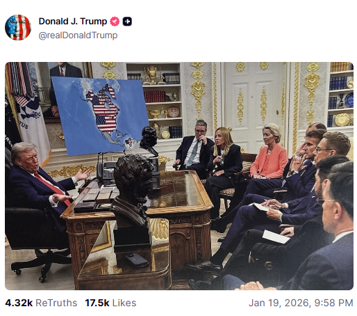
The map is part of an AI-generated image taken from a real White House photo, taken on August 18, 2025. The image is taken during Trump’s meeting with European leaders to discuss the war in Ukraine.
Notably, the map of Ukraine from the image’s background has been replaced with the map of North America and the U.S. flag covering Canada, Greenland, and Venezuela, showcasing them under U.S territory. The people in the image include UK Prime Minister Keir Starmer, French President Emmanuel Macron, and Italian Prime Minister Giorgia Meloni, looking at the map.
Also Read: Israel vs Iran: How the Two Countries Compare in Air Power
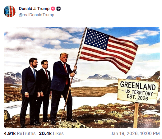
It is widely comprehensible that the image is controversial. Shortly after the post, Donald Trump also shared another AI image, showcasing himself, Vice President JD Vance, and Secretary of State Marco Rubio planting an American flag on a snowy landscape.
The post has a caption: “Greenland, U.S. territory, Est. 2026.”
Geopolitical Context of Trump’s New U.S. Border Map
Notably, the map is not a meme but rather a reflection of Trump’s recent administration action and statement. It is also seen as a hint at the upcoming actions from the U.S.
At the beginning of the year, the U.S. executed a military operation in Venezuela, capturing President Nicolás Maduro and his wife. The inclusion of Venezuela is understandable since Trump has stated that the U.S. would run the country and oversee its oil resources during the transition.
Even he shared a fake Wikipedia page listing him as the “Acting President of Venezuela.”
The inclusion point for Canada is also not new. Donald Trump has repeatedly suggested making Canada the 51st state. While no military action has been suggested yet, this idea has invoked trade disputes.
Trump also believes that the acquisition of Greenland by the U.S. is an absolute necessity for national security. He claims that it’s important that it happens so they can prevent Russian or Chinese influence in the Arctic.
In his attempts, Trump has even threatened a 10% tariff on European countries that are backing Denmark to not sell the territory. In the series of events, Trump has also shared the screenshot of his conversation with Nato chief Mark Rutte, in which Rutte appeared to say: –
“I am committed to finding a way forward on Greenland.”
International Reaction to Trump Claiming Canada, Venezuela, and Greenland as U.S. Territory
People from all around the world have shown mixed reactions to Trump’s AI map, mostly calling it alarming and outrageous. Even Canada’s Prime Minister Mark Carney has called this suggestion unrealistic.
The European Union leader has called the posts “provocative” and a threat to the NATO alliance. The Danish government again reiterated that Greenland is not for sale and has ordered its forces to attack if attempts to invade are made.
Why is all this happening now?
Since the beginning of the year Trump has been quite active in such controversies. Starting with military action in Venezuela to announcing the Board of Peace for Gaza. Now, Trump has shared this controversial map claiming Canada, Venezuela, and Greenland as U.S. Territory.
Analysts call it the part of the 2025 National Security Strategy, which introduced a “Trump Corollary” to the Monroe Doctrine. The strategy favors setting America’s dominance in the Western Hemisphere. More importantly, treating the geographic proximity as a source of “leverage” for the United States.